Lost Roads: The Hand-Painted Signs and Color-Coded Routes That First Taught Americans to Drive Across the Country
Lost Roads: The Hand-Painted Signs and Color-Coded Routes That First Taught Americans to Drive Across the Country
Every road trip you've ever taken — every highway merge, every exit ramp, every moment you glanced at a green sign and knew exactly where you were — rests on a foundation laid more than a hundred years ago by a surprisingly disorganized group of boosters, tinkerers, and motoring enthusiasts who were essentially making it all up as they went along. Long before the interstate system, long before standardized signage, and centuries before anyone could ask their phone for directions, Americans had to figure out how to move across a continent by car with almost nothing to guide them.
The story of how they managed it is the hidden backstory behind every road trip Americans still take today.
The Roads Were There. The Signs Were Not.
When the automobile arrived in the United States at the turn of the twentieth century, the country's road network was a patchwork disaster. Most roads outside cities were dirt tracks designed for horse-drawn travel — muddy in spring, rutted in summer, impassable in winter. There were no standardized route numbers, no consistent signage, and no reliable maps for drivers. If you wanted to drive from New York to Chicago in 1910, you were largely on your own.
The first response to this problem didn't come from the government. It came from private motoring clubs and automobile enthusiasts who began organizing what they called "named trails" — long-distance routes with evocative names that were marked with painted symbols on telephone poles, fence posts, and rocks along the way. The Lincoln Highway, established in 1913, was among the most ambitious: a route stretching from Times Square in New York City to Lincoln Park in San Francisco, marked with red, white, and blue bands painted on whatever vertical surface was available.
The Lincoln Highway Association promoted the route aggressively, lobbying local governments to maintain the roads along the path and publishing early guidebooks for motorists. It was the country's first coast-to-coast automobile route, and it worked — not perfectly, and not without confusion, but well enough to prove that Americans would drive long distances if someone gave them a reason to try.
The Chaos of Competing Systems
The named trail model caught on fast, and then immediately became a problem. By the early 1920s, there were hundreds of named trails crisscrossing the country, each maintained by its own booster organization, each with its own color scheme or symbol painted on roadside markers. The Dixie Highway. The National Old Trails Road. The Yellowstone Trail. The Ocean-to-Ocean Highway. Travelers navigating through any major intersection might encounter a telephone pole plastered with a dozen different painted bands, each pointing in a slightly different direction.
The situation was, by most accounts, maddening. Route markers frequently contradicted each other. Some trails were well maintained; others faded and disappeared without notice. Local boosters sometimes painted fake markers to redirect traffic through their towns, a practice that became common enough to earn its own nickname among frustrated drivers.
Private businesses stepped into the vacuum. Oil companies began publishing their own road maps — often given away free at gas stations — as a way to build brand loyalty and keep drivers on the road longer. Rand McNally, which had been producing railroad guides since the 1870s, pivoted to automobile road atlases and found a massive new market. The American Automobile Association, founded in 1902, began posting its own directional signs and dispatching "pathfinders" to scout and document routes for members.
Washington Steps In
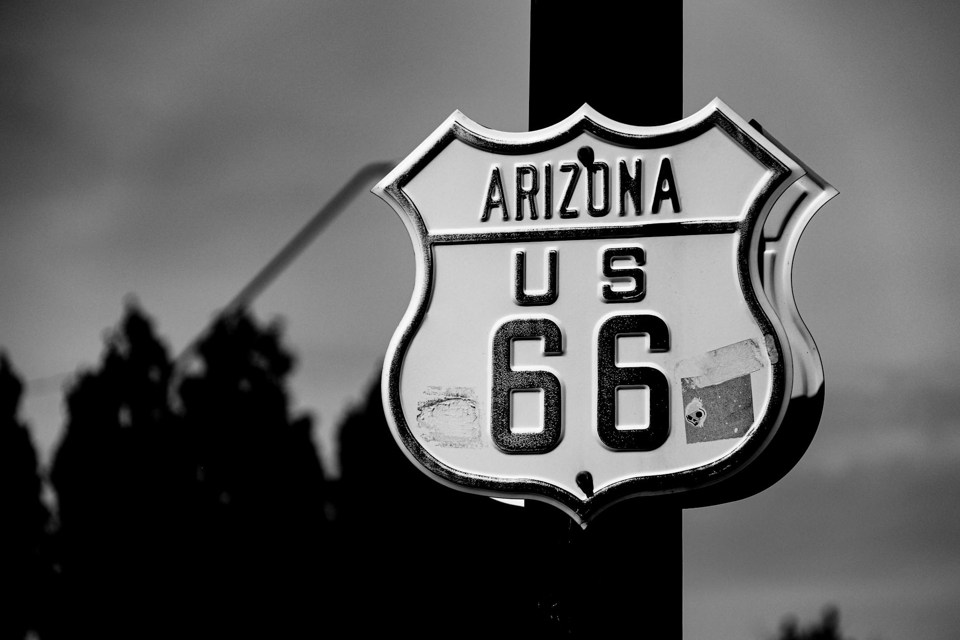
The federal government's response came in 1925 with the establishment of the U.S. Numbered Highway System — the familiar network of U.S. routes (US-1, US-66, US-101) that replaced the chaotic trail-naming system with a logical, standardized grid. Even-numbered highways ran east-west; odd-numbered routes ran north-south. A uniform shield-shaped marker, instantly recognizable, replaced the painted bands and competing symbols.
Route 66, commissioned in 1926, became the most iconic of these new numbered highways — connecting Chicago to Los Angeles and passing through the kinds of small American towns that would define the mythology of the open road for generations. The numbered system didn't immediately fix every problem (many roads were still unpaved, and the maps weren't always accurate), but it gave American drivers a shared language for the first time.
The roadside infrastructure that grew up around these routes — the diners, the motor courts, the Burma-Shave advertising signs spaced along the highway to be read at driving speed — created the visual and cultural texture of American road travel that still echoes in how we think about hitting the open road.
The Interstate and What Was Lost
The Federal Aid Highway Act of 1956 launched the interstate system and fundamentally changed the nature of American road travel. Highways became faster, safer, and more uniform. The old U.S. routes were gradually bypassed, and the towns that had grown up along them — dependent on through traffic — began to hollow out.
What was gained in efficiency was offset by a loss of texture. The hand-painted markers, the competing booster organizations, the quirky regional guidebooks — all of it receded as the green-and-white interstate signs became the dominant visual grammar of American travel.
GPS finished the job. Today, most drivers couldn't tell you the route number of the highway they're on, let alone the name of the trail that preceded it.
But the impulse that sent those first motorists out onto unmarked dirt roads with a painted telephone pole as their only guide — the desire to see the country, to move through it freely, to find out what's around the next bend — that part hasn't gone anywhere. It just looks different now.